The world is slowly opening back up. You might be finding yourself using public transit for the first time in ages and trying to figure out how to get around. Some helpful new Google Maps features could help us all navigate through this time, both literally and figuratively.
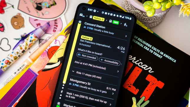
For folks finding themselves back on a bus or a train, Google is expanding its transit crowdedness predictions. The company now works with more than 10,000 transit agencies in over 100 countries to deliver you real-time predictions on how many seats are on the train. Maps will let you know if there are open seats or none at all to help you get a better idea of when to hop on for a ride. In New York and Sydney, Google is even piloting the ability to see live crowd data down to each transit car. You’ll know you have the ability if you see a colored “Live” indicator, along with whether the line you’re taking is “busier than usual” or “not too busy.” For trains, you’ll even see numbers indicating which train cars are the least populated.

While you’re on that train, you might be wondering what it is you’re doing with your life. There’s a new feature to help deal with that, too, called Timeline Insights. Google Maps will aggregate what you’ve been doing with your life, and where you’ve been going, provided you turn on your Location History. Maps will track how often you shop or eat out, and whether you drive, fly, walk, or bike to get there. The feature is available in the Timeline tab, which is accessible behind your profile photo in the Google Maps app.
Then, when a friend asks you for suggestions based on a trip you took somewhere in pre-pandemic life, you can flip through the Timeline and tap on Trips to check out where you’ve eaten and the monuments you walked by. Turn on the option to select them all, and then add them to their own list and export the itinerary to a friend. And if you’re subsequently creeped out by that, you can scrub the data entirely with Google’s auto-delete controls.
Lastly, while you’re safely eating your way around town this summer, Google is encouraging you to offer up useful information. Once you leave a review, Maps will ask you additional prompts, like price ranges and whether you ordered takeout or delivery.
The new features are rolling out now to Google Maps on both Android and iOS.