For the first time ever, geologists have used an aerial drone to map the interior of a giant blowout crater, the likes of which have appeared with increasing regularity in Siberia. The resulting 3D model, along with other data collected during the survey, is bolstering the prevailing theory linking these bizarre holes in the tundra to increasing heat.
“Over the years we’ve gained a lot of experience with surveillance drones, yet this underground aerial survey of the C17 crater was the most difficult task I had ever faced, having to lie down on the edge of a 10-story deep crater and dangle down my arms to control the drone,” Igor Bogoyavlensky, a geologist with the Oil and Gas Research Institute at the Russian Academy of Sciences, said in a statement.
Bogoyavlensky said he came close to losing the drone on three occasions, but he “succeeded in getting the data for the 3D model,” the details of which have now been published in the journal Geosciences.

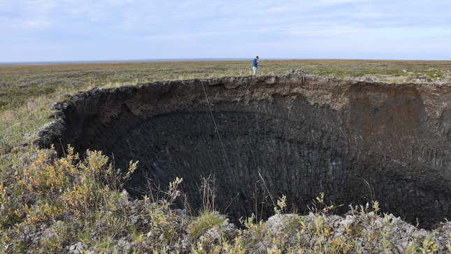
Andrey Umnikov, a co-author of study and director of the Russian Center of Arctic Development, was the first to spot C17 which he did from a helicopter in July 2020. The 98-foot-deep (30-meter-deep) hole is located in the Yamal Peninsula of northwestern Siberia, and it’s situated near three other blowout craters, including Yamal crater, the sudden appearance of which alerted the world to this strange phenomenon back in 2014. The one the researchers study opened up this past summer amid record heat.
The going theory behind these craters, of which 20 are known to exist, is that they’re the result of melting permafrost. As the Arctic warms, gas, mostly methane, builds up inside cavities located at the top layer of permafrost. Eventually, the ground is no longer able to contain this pressure, and it gives out a mighty burp in the form of a gas explosion, tossing out material (ejecta) and forming a crater, according to this view. Blowout holes don’t last for very long, as they quickly fill up with water and transform into lakes.

Hence the urgency in organizing an expedition to study C17 in detail, and to do so as quickly as possible following its discovery. The team, which included experts from the Skolkovo Institute of Science and Technology, visited the hole on Aug. 26, 2020—approximately 40 days after it was first spotted.
Upon arrival, the team noticed that the hole had increased slightly in size, the result of further melting and collapsing rock. Measurements showed that the depth of the hole wasn’t uniform, ranging between 95 to 108 feet (29 to 33 meters) in depth.

“The new crater is impressive in its ideal state of preservation, primarily the cone-shaped top where ejecta was thrown from, the outer parts of the heaving mound that precipitated the crater, the walls of the crater itself which are incredibly well preserved, and, of course, the gas cavity in the icy bottom of the crater,” Evgeny Chuvilin, a co-author of the study and a scientist at the Skoltech Center for Hydrocarbon Recovery, said.
Bits of ejected material were spotted as far as 720 feet (220 meters) from the crater, highlighting the strength of the explosion.
Importantly, the team arrived in time to find the hole in an “almost pristine state” and with “no water filling it,” said study co-author Vasily Bogoyavlensky. At the same time, the icy dome largely remained intact. Prior to the explosion, the cavity contained a circular dome with an elliptical bottom, explained Bogoyavlensky, to which he added: “From what we know we can say that the C17 crater is linked to...deep fault [tectonics] and an anomalous terrestrial heat flow.”

Igor Bogoyavlensky piloted the aerial drone, marking the first time that a drone was used to survey a blowout crater. It was also the first opportunity for scientists to study a relatively new crater that hadn’t collapsed or filled up with water. (Scientists have climbed inside these things before, but only after mostly filling up with water.) The drone, which got as deep as 50 feet (15 meters), collected valuable data, allowing the team to build a 3D model of the crater interior. The researchers also documented features not visible from the surface, such as grottos and a suspected cavern at the bottom.
According to the 3D model, the crater has a diameter of around 82 feet (25 meters), while the gas cavity at the bottom measures between 43 to 49 feet (13 to 15 meters) wide. The gigantic chunk of dirty ground ice in the crater measures 75-feet-thick (23 meters) in some places. The total volume of the underground space is estimated at 353,000 cubic feet (9,910 cubic meters), including about 265,000 cubic feet (7,500 cubic meters) of ice.

The team also looked at remote sensing data collected by helicopter and satellites, the latter of which showed that the C17 hole formed at some point between May 15 and June 9 of last year. Research published earlier this month used satellites to discover even more holes in the tundra as well.
Taken together, these observations strengthen the theory about how these holes are created: The steady accumulation of gas inside a subterranean cavity leads to tremendous pressures, leading to the formation of a “perennial heaving mound,” or PHM, according to the study. Should the growth of a PHM reach a critical threshold, a volcanic-like explosion ensues, forming a large crater.
“The specific shape of the underground cavity in the massive ice, the structure of which is depicted by a digital 3D model, is of great importance for the factual confirmation of the model of cavity formation,” wrote the authors in the paper. “It proves the model of its formation in the massive ground ice, the gas-dynamic mechanism of the PHM formation and powerful gas blowout with the destruction of the arch part of the underground cavity and the PHM itself.”
Looking ahead, the scientists are hoping to learn more about the gas and where it comes from, how it accumulates within the cavities, and how this can result in such a powerful explosion. The team expects to revisit the C17 blowhole later this year to continue its investigation of this curious natural phenomenon with a human-induced twist.